Sunday 30 December 2012

G4OBK Beverage Antenna now repaired

The hedge cutting which took place in November savaged my western beverage antenna - so today I repaired it.

Feedpoint of my beverage antenna
This inexpensive long wire aerial, which is mounted beween three and five feet above ground, is fed by buried 50 ohm RG-58 coax. The feeder is then connected to a home made 9:1 ferrite balun transformer.  The 475 feet length aerial is then terminated to ground via a carbon resistor network of around 500 ohms at the opposite end to the coax feeder.

This receiving aerial is directional and favours signals in the direction of the Yorkshire Dales, Lake District and USA. In effect the aerial comes into its own between a frequency span of 500 KHz up to 7 MHz and is very effective at picking up signals in a span from South America  (215 degrees) round to Alaska (340 degrees). Use of this directional antenna allows me to listen to Manx Radio on the Isle of Man on 1368 KHz, as it nulls out the stronger signal from BBC Lincolnshire on the same frequency.

The aerial performs extremely well on the 160m band (1.8MHz) but I have also found the beverage antenna excellent for receiving DX communications on the 60m (5 MHz) band when used in conjunction with a 1/4 wave vertical antenna for transmitting. The aerial design is used commercially by government agencies.  Some radio amateurs are using 12 of these antennas covering each 30 degree point of the compass. 

Harold Beverage in his 1920s radio shack
The aerial needs to be some distance away from the transmit antenna or induction takes place. This can ruin the performance of this low noise receive antenna. 

Harold Beverage an American engineer, conceived this antenna. He died in 1999 at the age of 93. He was Chief Research Engineer for RCA in the USA from 1929 until 1940 and continued to work in the field of communications for the rest of his life.  
 
(In Nov 2016 I moved to a new address one mile from the one where I had the Beverage - no chance of getting anything out that long at my new QTH unfortunately). 

Tuesday 18 December 2012

Cross Fell G/NP-001 G4OBK & G0VWP

The summit of Cross Fell is the highest point in the North Pennines at 2930 ft.  The plateau on which the summit lies also carries Little Dun Fell and Great Dunn Fell where a NATS air traffic radar installation is located. The large white radome can be seen on a good day from the A66 in the Eden Valley.  The average annual rainfall on the summit is around 110 inches and the summit can be an inhospitable place, especially when the cross shelter on the summit is covered in a snow drift, as it was on our visit of 18 December 2012.

The snow and ice meant we could not proceed further by car than this point - Terry G0VWP is pictured
On my previous visit in December 2008 the weather was cooler, with mist and a hoar frost. Today there was more lying snow, patchy thick mist and wind of around 20 mph on the summit. In addition it was not possible to reach the usual parking place at the radar station gate (NY 716316 2480 ft ASL) due to ice and lying snow on the access road, so Terry parked the car in a passing place at NY 712306 at 2000 ft ASL. 

The road up Dun Fell to the usual parking place was impassable due to snow and ice
I've known Terry personally for just over a year, although we have made contacts on ham radio regularly since 2009. He lives in York, around 30 miles from my home in Pickering. 

Terry picked me up at 06.00 am and we were parked up on the road and walking by 0835 am. As we got nearer the gate the road conditions became worse and it was plain to see that the only vehicle which had climbed as far as the gate had caterpillar tracks. We continued on the road to the second gate which is the perimeter of the Great Dun Fell Radar site and then turned off right to follow the fence which (eventually) led us to the Pennine Way. 

Phil G4OBK on Great Dunn Fell
As we continued the partly frozen snow and mist made progress difficult and we ended up crossing a shake hole some distance off the Pennine Way before we eventually found it. The route taken meant we crossed on the south west flank of Little Dunn Fell. 

A GPS plot of the middle section of our route out and back
If you look closely at the map you will see that when we passed the Shake Hole that we had to back track. This was when Terry had noticed he had lost his glasses - a 20 minute search returning back to where we had stopped to check and correct our position was unsuccessful - the glasses were not found....

Terry G0VWP en-route to Cross Fell
We continued on to the depression of Crowdundle Head which is the source of the River Tees.

At Crowdundle Head - the depression on the plateau between Little Dun Fell and Cross Fell
From here the trig point and shelter were a long time in coming. With the thick mist you could not see the join between sky and snow at times, however we eventually made it.

Approaching the summit of Cross Fell
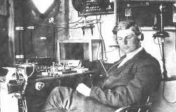
Terry G0VWP in his operating position on HF - no need to guy the pole as it was supported in a snow hole

After we had kicked some of the snow out of the way Terry set up his station for VHF on the 2m band in one corner of the shelter. After I had a sandwich and flask of tea I set up my HF Short Wave station on the opposite side. We both used separate Yaesu FT-857 transceivers. 

Terry operated entirely on voice using FM and SSB on the 2 Metre Band and then on the 20m Band using my station. I operated in Morse (CW) on 30m, 20m and then on 2m VHF on FM and CW using Terry's station.  We used a link dipole on HF on a 7m pole and a SOTA Beams MFD on VHF mounted around 2m above ground. Using SSB on 2m with the MFD Terry G0VWP worked as far south as Devon when he worked Don G0RQL. The only station I worked on 2m CW was John G0TDM in Penrith. Our final total in 90 minutes operating was 113 contacts with 25 countries, the furthest on HF being with USA, Canada and Asian Russia. 

Terry operating HF SSB on the left - the VHF station is on the opposite corner of the cross shelter
Here is a short film of me on youtube on the summit shot by Terry.

We left the summit at 1.20 pm. Needless to say my hands were frozen as it is not possible to operate a Morse key for over an hour with gloves on.  However I recently purchased some German Army Surplus fur lined mittens which I was carrying. Without any liner gloves my hands were warm as toast within five minutes! A good purchase....

My "new" German army surplus fur lined mittens
We saw no other person and no wildlife, apart from one earwig crawling over the surface of the snow! 

The only living creature seen on our walk
As we made our way back over Little Dun Fell on the better return route, we  found part of the flagged section of the Pennine Way uncovered by the snow. The mist was clearing from time to time and this allowed us views over the Eden Valley and down to Dufton Pike (G/NP-027) below us. 

Dufton Pike and the Eden Valley on our return (1.40 pm on 18 December 2012)

Once we reached the radar station and the road we could see that there was a light thaw on and the gate to the station had been unlocked. Again there were only catterpillar tracks, so the maintenance crew must use a specialist vehicle which is kept in a nearby village to access the station during the winter months. 


The final picture above was taken as we headed down to the car. We completed what was an arduous walk of 8.5 miles with 2000 feet of ascent at 3.15 pm. As Terry's eyesight was affected by not having his glasses I drove his car back to Pickering. 
I will be revisiting the summit on May 1st 2013 with Geoff M6PYG when we will again operate for Summits On The Air, whilst taking part in Wainwright's Pennine Journey, a long distance walk of 247 miles. 

Wednesday 12 December 2012

A walk up to Urra Moor - Round Hill TW-001 from Chop Gate (Yat) Car park

My view over the Cleveland Hills on 12 December 2012
My route to Round Hill from Chop Gate (Chop Yat) Car Park 
The ice bound car park at Chop Gate (Yat) 12th December 2012
December 12th 2012 - the twelfth of the twelfth of the twelfth, a quite unique date and it was time for my annual visit to the highest point of The North York Moors - Round Hill. As the SOTA Regional Manager for the TW - Tees to the Wash region I try to visit all summits every year if possible, it is not too dificult as there are only five to monitor, although I have to admit I seldom visit the "pimple" of Normanby Wold in Lincolnshire, as I rarely go down that way.

I had dropped my wife Judy off at the Ryedale Folk Museum in thick mist where she works as a volunteer and proceeded on to Bilsdale. I left the mist below me as I passed the Hawnby junction on the Helmsley to Stokesley road (known by some as the "Yorkshire TT").  

Treacle ready for off in her fleece lined sports coat
Treacle our cross Border/Lakeland terrier accompanied me on this solo walk, and I left the car park at Chop Yat via a route I hadn't taken before. This was a longer and more adventurous walk, rather than my usual route from Clay Bank car park up the Cleveland Way. The temperature on departure at 10.30 am was -4c, with no wind so it was pleasant for walking.

My view to the Clay Bank gap
The other benefit of this walk to the summit was that I could recce a few more footpaths and bridleways which I hadn't walked before to assist with the planning of any future walks which I lead for the walking groups I help to run. 

The Byre near to Medd Crag - inside and outside views
It took me 75 minutes to walk the 3 miles to the summit, passing south of Bilsdale Hall and then taking the bridleway to pass the byre below Medd Crag.

Shooters track junction with the Cleveland way - this is within the activation zone for TW-001
The old bridleway has become a shooters track now and today it was snow bound, but the walking was easy as I had plenty of grip. The air was clear, unlike back in Helmsley and in the Vale of Pickering where I live, which was fog bound all day.

Visitors are welcome on the grouse moors - information board within the activation zone for Round Hill TW-001
It was the shooting season and there were plenty of grouse on the moor today. The sport is big business on these moors with rich people paying well in excess of £1000 per day to bring their guns up here. I could hear shooting some distance away, but fortunately this was not taking place on either Bransdale Moor or Urra Moor today. 

One of  the very shy grouse of Urra Moor
I reached the trig point and set up my transceiver. I was running the higher power today of 30 watts (Rig - Yaesu FT-857) from an 11.1v lithium polymer battery, and it paid off with contacts as far as Lancaster (Sue G1OHH (FM)), Ulverston (Dave G6LKB (FM)) and Welshpool (John GW4BVE 144 miles (SSB)) in Wales.  The only CW (Morse) contact I made was with Roy G4SSH in Scarborough. I did hear Kevin G0NUP but he wasn't hearing me sufficiently to complete the Morse contact. The contact I had with G6LKB was made at 12:12 on 12 of the 12 in 2012!

Treacle feeling cold and getting ready to leave at the end of our 45 minute stay on the summit
The trig point on Round Hill has a hole in the top wide enough to take the shaft of a walking pole and this was used to support my vertical dipole, giving me a little more elevation for the antenna.  

The afternoon mist blowing up Bilsdale from the Helmsley direction - Tyne Tees TV Transmitter mast visible
I completed 22 contacts, had my lunch and set off back to Chop Yat using the same shooters track, however when I reached Medd Crag I continued along the ridge to take the slant bridleway down into East Bank Plantation and returned to Seave Green that way, reaching the village hall car park and toilets by 2.20 pm. On account that I was on access land and that this was a prized grouse moor my dog had remained on her short lead all day. 
Bilsdale below me on my way back down
The time was right for me to collect XYL Judy from Hutton le Hole on our way home on what was her last day of work at the Folk Museum this year. 

Distance walked: 6.7 miles - 1200 feet ascent


 Contacts made from Round Hill by G4OBK/P

Saturday 1 December 2012

A weekend in the Welsh Borders and the Brecon Beacons Day One

My fellwalking friend Geoff lives in Malvern and had invited me down to stay with him and his lovely wife Eva some time ago. At last the chance came to visit and walk in the Welsh Borders and Brecon Beacons. My visit coincided with the Winter Bonus period for Summits On The Air - this applies in the UK from December 1st to March 15th when activators making contacts from summits over 500m ASL are entitled to claim a 3 point per summit winter bonus. 

I drove down from North Yorkshire and arrived in Cradley near Malvern by 2.00 pm. After a quick cup of tea Geoff suggested we walk to the Worcester Beacon. This is a Marilyn Summit which I could see from the house, and one Geoff had climbed previously. At 2.45 pm we left on what was an 8.5 mile walk, so it was obvious we would be returning in the dark. The weather was fine, after previous days of heavy rainfall and flooding near the rivers and watercourses of the area. 

Our route from Cradley to Worcestershire Beacon
This walk was predominantly on fields paths and through woodland and we passed a large complex of buildings connected with the Elim Church, a Pentecostal Christian faith at the foot of the beacon. 
Our view back to Cradley on our walk to Worcestershire Beacon
The hills here were covered in footpaths with the undulating ridge stretching from North Malvern down to Upper Wyche and then continuing to climb back up to the Herefordshire Beacon, a distance of around four miles.  We arrived on the summit at dusk and made 11 contacts for Summits On The Air using a 2m FM handheld connected to a half wave dipole vertical rucksack antenna, before we left at 4.35 pm. The winter bonus did not apply here on two counts - the summit is only 425m high and it was still 30 November. The bonus comes in on 01 December and the summit needs to be at least 500m high. 

Leaving Worcestershire Beacon at sunset - there were still plenty of walkers around
We soon needed our lights for our return to Cradley - me with my small Varta LED hand torch and Geoff with his Petzl headlight. We arrived back at 6.00pm and were surpised we had covered over 8 miles and activated a summit for SOTA in just over three hours. 

....to follow next day: The "Favourite Five" - four short climbs up to the Welsh Border Marilyn Summits over 500m in height and the Mid Wales Summit of Cordon Hill.    

The favourite five summits in the Welsh Borders

6.45 am on Saturday 01 December and Phil G4OBK and Geoff M6PYG departed Cradley, near Malvern on an 120 mile road trip up into Shropshire to climb and activate for Summits On The Air (SOTA) the four highest points in the Welsh Borders. After these four our intention was to drive over the border into Wales to climb and activate Corndon Hill. These are the summits we climbed in the order of our road trip:

WB-004  Titterstone Clee Hill  533m (arrive CP SO 594776 @ 0759z depart 0835z)
WB-002  Brown Clee Hill  540m  (arrive CP SO 585869 @ 0915z depart 1020z)
WB-005  Long Mynd - Pole Bank 516m  (arrive north end CP SO 421953 @ 1105z depart 1212z) 
WB-003  Stiperstones  536m (arrive CP SO 396977 @ 1230z depart 1340z)
MW-013  Corndon Hill  513m (arrive CP SO 301974 @ 1410z depart 1525z)
This circuit is known as the "Favourite Five". This is because it is an attractive proposition for SOTA activators in the winter to accrue 25 points in a day from five easy to climb summits without doing an epic walk. To do this in winter daylight hours the car has to be used to get from summit to summit. 

As take off in all directions is excellent plenty of contacts can be had using simple low power equipment, so all we carried was a Yaesu VX-170 5 watt handheld and a vertical dipole rucksack antenna. 
 Geoff M6PYG in the shelter on Titterstone Clee Hill WB-004
Titterstone Clee Hill, a worked out quarry with a National Air Traffic Control installation on the top of it is like the surface of the moon. It is not a pretty sight, but the view from the top is. I'd been here before, in 2008. 

After several brief VHF ham radio contacts for SOTA we headed back downhill to Geoff's car parked in the bottom of the quarry. I was navigating today, something I'm reasonably good at being a former holder of an RAC Motorsports Navigators National Grade Competition Licence in the 1980s:

The writer navigating on a night rally in a Ford Escort Mark One - Mid-Wales 1980
Our next destination was Brown Clee Hill WB-002, 6 miles north. I was enjoying my time "on the maps" again calling the bends out to Geoff, it took me back to a previous life. I gave up rally navigating in 1985. It got rather expensive and the sport had changed with less emphasis on rallying on public roads. It had become too fast and competitive and the police were starting to take an interest in what was happening.  

Parking spot at the start of bridleway up to Brown Clee Hill WB-002
Back to walking and SOTA - the Shropshire Way took us up to the summit of Brown Clee Hill and guess what - we found another radio station as well as the one we set up ourselves! We walked into mist and were blasted with hailstones for a short period on the summit. 

The writer Phil on the summit of Brown Clee Hill WB-002
A mountain biker (with two year daughter in the cart and following dog) arrives on the summit of Brown Clee Hill
Time to move on - north west towards Church Stretton and up the tortuous road to the summit of Pole Bank on the Long Mynd. The road sign said "Closed due to icing and snow". This didn't deter us and we continued uphill in the AWD Subaru without problem. This is quite some road and unprotected to the right where there is a 400 foot sheer drop into Carding Mill Valley.  Our walk from the northern car park up to Pole Bank was on a graded track with minimal ascent. 

Phil G4OBK and Geoff M6PYG on Pole Bank WB-005 - part of the Long Mynd ridge
This summit was busy - the mountain bikers outnumbering the walkers. We stayed long enough to make contact with 15 stations including Barry MW0IML/P who was in North Wales on the summit of Carnedd Llewelyn NW-002. 

Red kite - library picture
On our drive to Stiperstones I sighted a red kite following our car at close quarters, I got a photograph, sadly not good enough to place on this blog. I've seen these birds five or six times now in the Yorkshire Wolds, near Harewood north of Leeds and now in Shropshire. They were almost extinct when I was a kid and their re-introduction by conservationists and bird lovers remains controversial because of their alleged penchant for ground nesting birds nests. They are a beautifully coloured bird for sure. 

Stiperstones - this most distinctive hill is a quartzite ridge five miles in length and is owned and managed by the National Trust. This was without doubt our most outstanding location of the day and a place neither of us had visited before. A trig point is located on the top of its jagged highest point of  Manstone Rock and this is where we set ourselves down for 30 minutes in complete comfort. The sun was shining on the righteous and we had shelter amongst the rocks from the wind. To quote Wainwright "God was in his heaven". 

Geoff climbs up to the Stiperstones trig point
G4OBK Phil on Manstone Rock Stiperstones

This protected area suffered an horrendous fire in July 2012. The fire decimated part of the reserve and 70 fireman battled the blaze for seven hours with the smoke being seen many miles away. Little evidence of this was found around the area we visited. 


We made 12 contacts from the top, including one with Rob GW7LAS/P on the summit of Cadair Berwyn in North Wales. From our perch we had a good view into Powis, Wales and Corndon Hill - our fifth and final climb was seen most prominent four miles to the south west. 
Cordon Hill - site of special interest
We motored from the car park to Shelve and crossed over the A488 to reach the track leading to Corndon Hill. It was a steep ascent, something we are well used to and from the car to the top took us just sixteen minutes. From this point on we moved over to our Welsh callsigns of GW4OBK and MW6PYG. We made seventeen contacts before returning to the car and the drive back on mostly A roads to Malvern, which we reached at 4.45 pm. I took a break from navigation duties and let the Satnav do the work for Geoff. 

Geoff operating on our final summit of Corndon Hill GW/MW-013
This had been a most enjoyable day of road navigation, walking, climbing and amateur radio with 61 stations logged.

Brecon Beacons - Waun Fach GW/SW-002 from Dinas

I'm grateful to Dominik from Switzerland (HB9CZF) for providing the information from his website about this route starting from Dinas.

Route from Dinas

We had another early start from the home QTH of Geoff M6PYG who lives near Malvern, and were walking just after 8.00am.
The summit of Waun Fach is the second highest Marilyn Summit within the Brecon Beacons National Park. This was the second day of the 2012/13 SOTA winter bonus, and the activation of Waun Fach was worth 11 points if the 3 bonus points were included.

Parking place at Dinas (Room for 4-5 cars here)
The parking place we used is at the top of a narrow lane near Pengenffordd. This is just off the A479 Talgarth to Crickhowell road and lies at 1200ft, a good height to start the climb up to Waun Fach, which is 2661ft high. We could see we were in for a day of poor visibility and we lost our view within 30 minutes of starting the walk as we made our way across the flank of Y Grib, an outcrop on the climb. With visibility down to 100m it was not surprising we went slightly out on the navigation as you can see from the GPS track above, but we soon regained the correct bearing to make for Pen y Manllwyn which lies on the long plateau up to the summit. The ground was frozen once we reached 2000ft, with lying snow.  This was good, otherwise the mile long plateau would have been just one long eroded wet bog!

Waun Fach SW-002  - seen on the afternoon of our visit from Mynydd Troed SW-009
The summit was reached after 110 minutes, over a distance of 3.5 miles.  Our amateur radio operation for Summits On The Air (SOTA) was just about successful - we made five contacts the furthest being down to the station of Don G0RQL who lives near Holsworthy, a distance of over 90 miles. This was quite impressive on 2m FM with 5 watts of power and a vertical dipole. 


We did not stay on the summit long and as we descended the mist started to clear. 

On our way down to the cairn at Y Grib
We found a better track down than on the ascent and enjoyed visiting the cairn on Y Grib on our descent, as we couldn't see it in the mist on our way up. 

Geoff MW6PYG and Phil GW4OBK at the cairn on Y Grib
We reached Dinas at 11.45am and after a snack we made our way to the parking spot for SW-009 Mynydd Troed, which we could see from Dinas. The summit is on the opposite side of the A479 road at Pengenffordd.