Tuesday 30 July 2013

G4OBK SOTA Fair Snape Fell G/SP-007 July 2013

After leaving Hail Storm Hill I drove to Chipping, an old quaint Lancashire village north west of Clitheroe. I was familiar with the area having ridden a bike around there in the 1970s and 1980s from the area in which I grew up, 20 miles away.  My destination was the road leading up to Fell Foot, a cottage which lies beneath Parlick Hill. From previous SOTA activators reports I knew there was little point driving right up to the cottage so I parked near the Bowland Gliding Club windsock at SD 600443 and set off walking. 

Roadside parking for Fair Snape Fell 200m south of Fell Foot 
Follow the well defined route through the gate by Fell Foot Cottage

The path took me well to left of the gully and at SD 594448 I reached a fence. The path right went over Parlick but I continued straight on to skirt around the western flank to a col close to spot height 398 on the map.


Overlooking Fell Foot - Longridge Fell SP-013 and Pendle Hill SP-005 can be clearly seen

The terrrain reminded of me a walk I did some years ago on the grassy Howgills from Sedbergh up to The Calf via Arant Haw.


This had turned out to be an enjoyable and memorable evening walk with my target in sight throughout - the trig point and pile of stones on the summit of Fair Snape Fell G/SP-007. The route taken is shown below:


Distance walked was 4 miles return with 1000 feet ascent.
As well as enjoying my walk to the summit the air conditions were perfect for the sport of gliding. The Bowland Forest Gliding Club is based at the foot of the hill and several members seemed intent of buzzing me on my way to the summit and also whilst I was operating - here is one:


The ascent took me 42 minutes and I was on the air almost immediately as I was only carrying a Yaesu VX-170 5 watt handheld and vertical dipole for 2m FM.


I operated for 21 minutes and completed 11 contacts:


The view and VHF take off from the fell were superb, especially to the south. I made my way off on the grass path passing Nick's Chair, a feature on the map which I did not identify. (I didn't know that G4OOE had activated this summit, but I know Nick does like a sit down sometimes on his ascents!). On reaching the col I departed from my outward path to descend via the other side of Parlick. When I rounded the hill I saw a quick way down and was amazed how well my knees held up on the descent to Fell Foot. Total time taken for the whole activation was 102 minutes. 

I drove back the 100 miles home to Pickering with another two summits qualified for SOTA in the South Pennines, and another two ticked off my list of 176 English Marilyns.  

Monday 29 July 2013

G4OBK SOTA Hail Storm Hill G/SP-009 July 2013

GPS track of the route taken from my parking place
We had a wet morning on July 4th in Northern England but I was desperate to get closer to visiting all the Southern Pennines Marilyn Summits On The Air by activating two more over the border in my home county of Lancashire. 

With an improvement in the weather forecast at 2.00pm I left my QTH in Pickering North Yorkshire, for Hail Storm Hill, SOTA G/SP-009. The hill lies between the Rossendale Valley and Rochdale to the south of it. I allowed TomTom to direct me via the fastest motorway route to the north side of the hill, opting for what I believed was the shortest route to the summit on foot with the least ascent. I needed to save as much time as I could for later in the day for an evening activation of Fairsnape Fell G/SP-007.

The last possible parking place for Hail Storm Hill from the north (See text)
It was just after 4.00 pm when I parked up on Rooley Moor Road at SD 8466 2038, well away from any housing or industrial compounds. The parking place so far up that road is only really suitable for at least a "softroader" with higher ground clearance, fortunately that is what I now drive. Vehicles with lesser ground clearance, like my last motor, would be better parked further down the hill around the radio mast I would suggest at SD 8442 209, or even before that, as the road is narrow in places and quite steep. 

On arrival I realised that there was now a large wind farm on the plateau of Hail Storm Hill, my map dating from 2005 of course did not show this. Now to get those turbines up there they must have come from the opposite side of the hill as there was no way they were taken up on the tracks on which I walked to gain access to what is a rather wet and boring summit. So these days there may well be an easier access point with safe parking from the Rochdale side - go on, go find it and report back on the SOTA Forum or put on a link next to this one on the SOTA Summit Page

The track to the summit through SD 8465 1955 - no access for vehicles allowed on this track
Pennine Bridleway marker post
As I made my way up to the plateau above the small reservoir shown on the map as Cragg High Level Tank, I came across a couple of interesting features. After joining the Pennine Bridleway I reached the undulating mountain bike trails of Cragg Quarry and took to these on foot on my ascent.
Soon after, I left the track to pick my way around the less boggy parts of Hail Storm Hill where I tried to establish the highest point, which I found quite difficult on the top, which was featureless apart from the wind turbines. It had taken me 22 minutes to "reach my destination", and then later 19 minutes to return to my car after qualifying the summit for SOTA.  

So I stood there for twenty minutes in the middle of the moor with my vertical dipole rucksack special and VX-170 and made seven contacts on 2m FM before retreating back to my car:


I left the parking area by 5.30pm and drove across Lancashire via Whalley for my evening activation of Fairsnape Fell in the Forest of Bowland, almost 40 Km and a 70 minute drive to the north west of Hail Storm Hill. I made a wrong turning near Chipping and that added a good 10 minutes to my journey.

Would I return to Hail Storm Hill?

No, once bagged soon forgotten and the hill is not so good on VHF compared to other summits in the north west. Its great to visit new places though and say you've been there and experienced the location for yourself. That's one of the things I like about Summits On The Air. 

73 de Phil G4OBK

Tuesday 23 July 2013

Our Swallows take flight and a Little Owl at dusk

Every year for the past five years or so swallows return in the spring to nest in our porch. 

I took this photo around one hour before two of our three fledgling swallows took flight. As I write this one swallow remains in the nest. 


Two nights ago I had the back door open just as it went dark and heard what I thought was someone clearing their throat and inhaling. In fact making these noises was a little owl roosting on our roof. The photo below was taken when the owl moved position to the TV aerial and is unfortunately rather blurred.


Little Owl....the light was poor and without a tripod this was the best I could do....

Sunday 14 July 2013

A Welsh Borders Road Trip doing SOTA (Part One)

After travelling down to the home of Geoff M6PYG the previous afternoon from Macclesfield Railway Station when we activated four summits in three different SOTA regions en route (see report), we rose at 5.00am next day to get away early, on this road trip in the Central England and Welsh Borders area. Our plan was to drive from point to point activating eight of the Marilyn summits in the Welsh Borders for Summits On The Air on the 144 MHz VHF FM band. Geoff M6PYG was the driver, and Phil G4OBK was the navigator. The 170 mile road trip started from Cradley near Malvern and headed towards the Cotswolds for Bredon Hill, CE-003.

Our 170 road trip activating eight summits in the Welsh Borders and Central England 
We then went south to activate Cleeve Hill, CE-001 near Cheltenham before crossing the Vale of Gloucester to the National Trust owned May Hill, WB-019. From there we entered the Forest of Dean to visit Ruardean Hill WB-021, which has a public road running over the top of the summit. Moving closer to the Welsh border, Garway Hill WB-013, came next. We then headed north to the heavily wooded Burton Hill WB-020, before skirting Leominster to arrive at another "drive on summit" at Hegdon Hill WB-023. Going south our 8th and final activation of the day was on Seager Hill, WB-022 at 6.30pm. From there we headed back to the home QTH of M6PYG in Cradley for a BBQ and drinks.

Bredon Hill G/CE-003 

Arrive: 0705am
Depart: 0826am
2m FM Contacts made: 6 
Yaesu VX-170 5 watts & vertical dipole


An early start from Cradley near Malvern saw us arrive at the parking place for Bredon Hill G/CE-003. There is a parking area for around four cars in a cul de sac at grid ref SO 955384.

The bridleway leading to the top of Bredon Hill
The walk from car to summit took 35 minutes and we operated from the stone wall on the north facing escarpment. I really rate this summit. Good in all aspects, the walk in, the views and especially the prolific wild flowers at this time of the year. To make the summit more memorable we said "good morning" to a very posh attractive lady out riding her horse! 

The writer on Bredon Hill G/CE-003 8.00am 14 July 2013
There were lift conditions and we made contact with 2E0MIX in Whitehaven, distance 295 Km. Derek was the only DX contact. G0LGS Stewart, and 2V0MDJ were worked and they agreed to meet us on our next summit of Cleeve Hill near Cheltenham. We operated for only 15 minutes before making our way down via a different route from the stone tower pictured above, using a permissive path through grid ref SO 958399. 


Cleeve Hill G/CE-001

Arrive: 0904 am
Depart: 0950 am
2m FM Contacts made: 6 
Yaesu VX-170 5 watts & vertical dipole

Geoff M6PYG meeting 2E0MDJ Matt (left) G0LGS Stewart (right) on Cleeve Hill CE-001
Avoiding the centre of Cheltenham we made good time. On arrival at the car park, which is within the activation zone of Cleeve Hill we met our new friends Stewart G0LGS and Matt 2V0MDJ, two really helpful guys. We were to make contact with both on all summits activated that day. 

GPS track of operating position on Cleeve Hill
Contacts were hard to make on the flat topped Cleeve Hill. It took the best part of 30 minutes to complete six contacts. This included Stewart and Matt who drove into Cheltenham so we could add them to our total. From experience they told us the best place to operate from on the hill. Next time we'll carry the FT-857, although I doubt I will return to Cleeve Hill again. If in doubt take HF gear, but we didn't have time for that today with eight activations planned.
On this trip we were following a combination of TomTom to the village nearest the summit and then OS Landranger 1:50000 mapping to reach the parking places. TomTom however fouled up a little on this section. I think I may have programmed in the wrong village. We were bound for May Hill G/WB-019 but for some reason TomTom took us north to junction 10 of the M5. Realising this was incorrect we made our way south west beyond the Vale of Gloucester to reach the very restricted parking place for May Hill - grid ref SO 689212. You could park two cars here if your lucky. The walk to the summit takes ten minutes. 

The weathered silver jubilee plaque on May Hill


May Hill G/WB-019


Arrive: 1039 am
Depart: 1119 am
2m FM Contacts made: 6 
Yaesu VX-170 5 watts & vertical dipole

This was another very pleasant summit to remain on for some time on the kind of day we had, however with six contcts logged in ten minutes we were off. The best QSO was a summit to summit with MW0JLA Rod on GW/MW-004 Pen-y-Garn. 

We drove off passing through Mitcheldean. This was the first time I had been in the Forest of Dean. I was impressed by the dense wooded steep sided valleys - this is nice country. We were making for Ruardean Hill G/WB-021 and we knew this would be one of our two "roadside activations" undertaken that day.

Ruardean Hill G/WB-021  

Arrive: 1142 am
Depart: 1216 am
2m FM Contacts made: 9
Yaesu FT-857 30 watts & vertical dipole

Geoff M6PYG operating from the summit at Ruardean Hill, Forest of Dean
We set up on the village green near a flagpole - having made the "final ascent" from the car 100m away. Well, the summit has the necessary 150m prominence to surrounding land, although sat on that dais you wouldn't think so. We made contact with Rod MW0JLA again who was still on Pen-y-Garn. A quick lunch and we were off to Garway Hill G/WB-013.

Details of the rest of our road trip can be found in Part 2 

A Welsh Borders Road Trip doing SOTA (Part Two)


Another Welsh Borders SOTA Road Trip Continued....

Garway Hill G/WB-013

Arrive: 1254 pm
Depart: 1404 pm
2m FM Contacts made: 12 
Yaesu FT-857 30 watts & vertical dipole


Its now 1.00 local time and after an 18 mile drive from Ruardean Hill we have arrived at the parking area for Garway Hill, grid ref SO 444248. This is at the end of a white road which is shown as Mount Pleasant on the map. The road is accessible without problem in a normal car. A 12 minute walk and we are on the summit. On the way up we passed a pond on our right which was full of horses and ponies drinking:


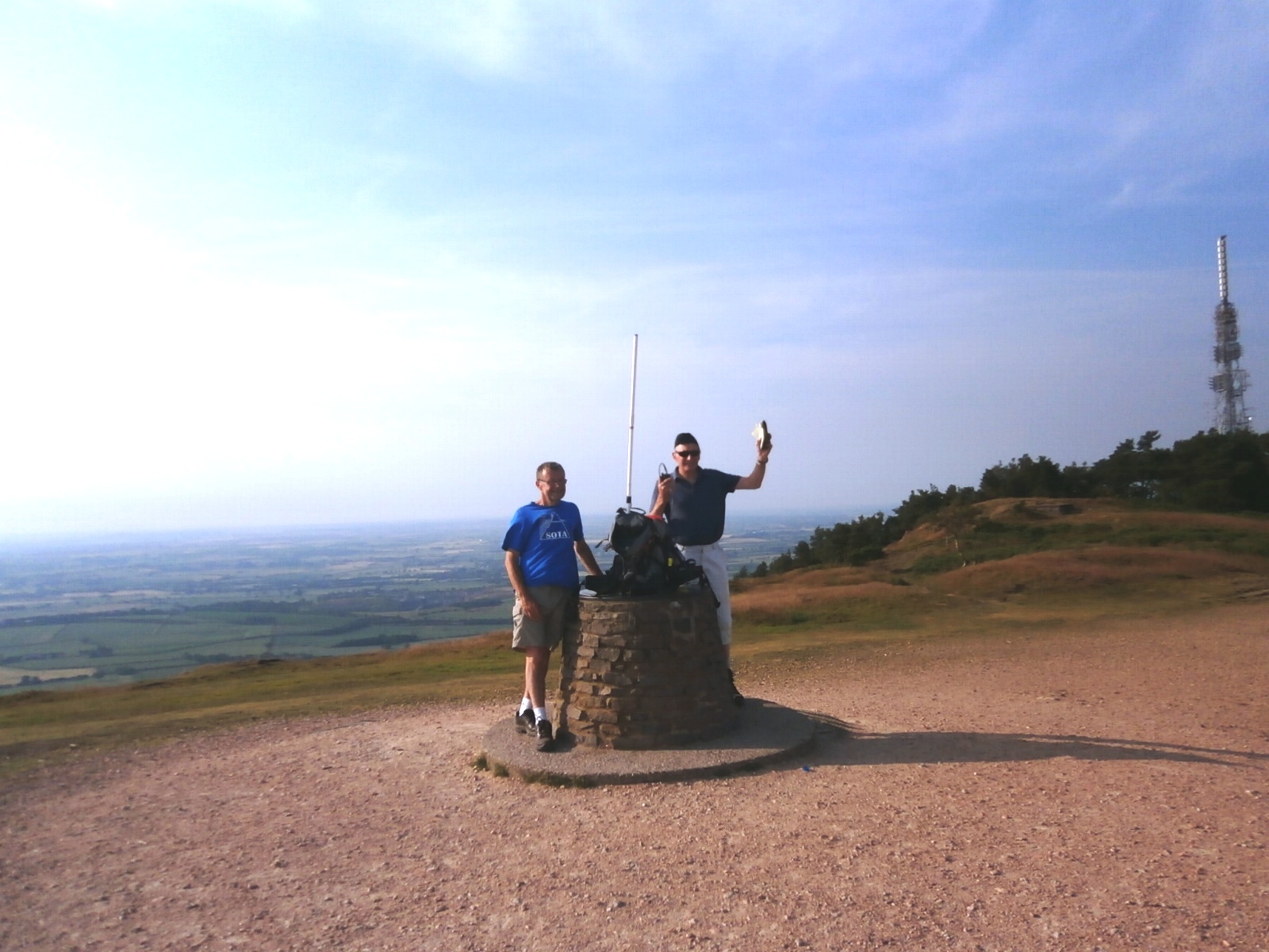
The trig and the remains of a World War Two radar unit soon presented itself at the summit and we set up the gear.


On the summit were two other "hobbyists". The guys were flying radio controlled gliders and we had a chat with them about ham radio, propagation and LiPO batteries. One of the guys knew a lot about radio propagation - he'd been a short wave listener in the 1980s. 

M6PYG - the glider men had carried up all their gear on a golf trolley 
We left the summit after 40 minutes. 

Burton Hill G/WB-020 

A 22 mile drive from Garway Hill found us parked up on a grass verge alongside the B4230 at Shoals Bank, grid ref SO 389494. This was the start of the 20 minute climb up the track (a private road) to the heavily wooded summit of Burton Hill. 


Arrive: 1450 pm
Depart: 1605 pm
2m FM Contacts made: 6 
Yaesu FT-857 30 watts & vertical dipole

We decided to locate the highest point of the hill which was in thick woodland WSW of the trig point.  I think this was probably a mistake, we should have gone left to the trig. We set up in the wood instead and found it difficult to both hear stations and propagate a signal. Towards the end of our 20 minute activity period we were called by G6UYG/P on Long Mynd G/WB-005. After that highlight we headed back down the hill to the car (15 mins). This is unlikely to be a summit I will return to.

Hegdon Hill G/WB-023

M6PYG operating on Hegdon Hill G/WB-023
A further 20 mile drive took us to our final roadside activation of Hegdon Hill. Geoff parked the car on the verge and we set up the station through a gate at the side of the bridleway leading to Little Hegdon. 

Arrive: 1649 pm
Depart: 1720 pm
2m FM Contacts made: 8 
Yaesu FT-857 30 watts & vertical dipole

An unremarkable activation (never to be revisited) but we made eight contacts and bagged another unique Marilyn for the SOTA tables. 

Seager Hill G/WB-022 

Arrive: 1802 pm
Depart: 1852 pm
2m FM Contacts made: 5 
Yaesu FT-857 30 watts & vertical dipole

A 16 mile drive took us to our last one of the day, 7 miles east of Hereford. We parked by a locked gate at SO 622379 and walked for one mile uphill in our determination to reach the actual summit at the trig point. After we went through a gate it became very overgrown but we ploughed on through the brambles and nettles until we could see the trig point the other side of hedge about 10m away from where we stood. 

You can see the trig point on Seager Hill to the left of the tree
We shouldn't have bothered going further than we needed to as it was so overgrown, so we returned down the track to a place we had spied on our way up at SO 6206 3832 where we had an open view where the trees had felled. This was at 250m ASL so we were well within the activation zone.  A 10 minute session produced five QSOs. We were happy with that so we went QRT and headed down to the car (5 mins) and back to Geoff's QTH near Malvern. If you visit Seager Hill then I advise against going as far as the trig point, at least during the summer. when the undergrowth is so thick. 

We returned to the M6PYG QTH near Malvern to enjoy a BBQ.

Geoff M6PYG, Phil G4OBK, Pip the dog and Eva XYL of  M6PYG
It came as quite a surprise that Geoff still had the energy to cook after all the driving, and we enjoyed a bottle of wine to finish off a satisfying day on the SOTA road, whilst we discussed our plans for the following day when we intended activating two more summits in the Welsh Borders region on my way back home to North Yorkshire. 

Overview of the day:

8.1 miles walked
1550 feet climbed over 8 summits (3 "drive on summits")
Each operator completed 58 contacts on 2m FM
162 miles driven in a clockwise rotation from Cradley near Malvern

Link to Welsh Borders Road Trip (Part One)

A Welsh Borders Road Trip doing SOTA (Part Three)

After staying and operating SOTA with Geoff (now 2E0NON) in the Welsh Borders for a few days I was homeward bound. With limited time due to the journey, just two summits were scheduled, and we took both cars out as Geoff had to return home to Malvern and I home to North Yorkshire. 

View Edge WB-018


Also known as Weo Edge, this summit lies 2 Km south west of Craven Arms. The highest point is in View Wood on private land. A public road traverses the col which is in the activation zone. There was room to park both cars at the track end at SO 42628057 this was gated but it had not been used for months as far as we could tell and there was nowhere else within easy range to park.

We chose to operate on the south side of the lane on the public footpath at SO 42448040. This was at 317m ASL, the summit top lying at 321m.

8.00am on View Edge WB-018 on July 14th 2013 M6PYG (2E0NON) and G4OBK
It was a beautiful morning and there was a lift on VHF extending the distance of the stations we worked and creating some interference. Our signals on 2m FM reached Essex when we worked Selim M0XTA in locator JO01bo, a distance of 225 Km. It was early morning and only six stations were worked in the 25 minutes we were on the air. We left the summit and headed north of Craven Arms to activate Callow Hill WB-015 next. 

Callow Hill WB-015

Easier route across the flank of Callow Hill - it took 17 minutes to reach the tower on the summit
There was plenty of parking space at spot height 214 and we had a steady walk up Callow Hill to reach Flounders' Folly, a most interesting and prominent Shropshire landmark. 

Approaching Flounders' Folly on Callow Hill WB-015
Information board for Flounders' Folly
The history of the Folly which was built in 1838, can be found here. The tower is locked, however there are open days shown on the website. I'm sure with an extra 80 feet and clear air all around you it would be well worth a visit with a 2m radio and rucksack special on one of the open days when it should be possible to operate with permission from the top. A charitable trust looks after the tower. It is now in excellent condition after a major restoration in 2004/5. 

We operated about 100m from the tower on the public footpath. The first contact was Summit to Summit with Allan GW4VPX/P on the highest summit in South Wales, Pen-y-Fan.  We followed this with seven more contacts and went QRT after 20 minutes.  

Heading home from Callow Hill after three days,  14 summits and 124 contacts.....

Saturday 13 July 2013

Shining Tor, Gun, The Wrekin and Walton Hill in a day

Midday on Saturday 13th July 2013 and I met up with Geoff M6PYG who disembarked from a train at Macclesfield Railway Station. I'd driven there from my home in Pickering for a few days activating Summits On The Air with Geoff. We were en-route to his place near Malvern, and in the Welsh Borders, but we activated four summits on the way down there. Our first stop was:

Shining Tor G/SP-004

Geoff M6PYG/P operating from Shining Tor
We parked across the road from the Cat & Fiddle Pub and walked up the 1.4 miles to the summit in 25 minutes. I've worked this summit from home so many times so it was interesting to see what it was like up there for myself. We made 16 contacts each on 2m FM with five watts and a simple vertical dipole fixed to an old fence post just down from the trig point, before making off back to the car for our onward journey to Gun, a summit near to Leek.

Gun G/SP-013

We arrived at the parking place for Gun which is at spot height 358 on the map and made our way up the moor to the summit. It was most pleasant and was easy to access. We stayed 30 minutes.

One of the easiest of summits to access - Gun SP-013 in the Staffordshire Moorlands
The writer operating for SOTA on Gun SP-013
It was 3.30pm when we left the Gun parking place to head south. Our intention was to make for Walton Hill near Halesowen, south of Birmingham, however the traffic news on Radio 2 changed all that. With the M6 being blocked by an accident we decided to detour to a prominent hill we had both driven past many times - The Wrekin G/WB-010.

The Wrekin G/WB-010

It was 5.25pm before we reached the parking place, partly due to the tailbacks of traffic caused by the RTA south of Stone. 

Our route up and down The Wrekin - a 30 minute ascent and a 23 minute descent
I don't think we chose the best parking place but there is plenty of room in the lane which passes Wrekin Farm so we left my car there. The views are excellent from this summit which was scarred by a wide gravel track right to the top. Shame about that. We again used the VX-170 and dipole. There was a degree of de-sense from the transmitters nearby on the summit but we found that by changing channel we could eradicate the problem.  


G4OBK Phil and M6PYG Geoff on The Wrekin G/WB-010
We'd spoken to another SOTA enthusiast earlier in the day when he was operating from Titterstone Clee Hill WB-004 and from Stiperstones WB-003. This was John M0JZH who lives close to The Wrekin in Telford and we made contact again with him again as he drove home. We subsequently met up with John at the bottom of the Wrekin for an eyeball, and to exchange stories, before proceeding on to our final summit of the day Walton Hill CE-002 where we again worked John back at home having had his dinner!  

Walton Hill G/CE-002

The M54 and M6/M5 were now free of congestion and this took us to the Clent Hills in just over an hour. It was only an eight minute walk from the car park at SO 943802 to the summit.

There were plenty of objects to fix our antenna to and we chose a rough hewn fence near the trig point. We stayed 35 minutes and had no difficulty completing 13 contacts on 2m FM with the extra power afforded by a Yaesu FT-857. 

Arriving in Malvern later in the day due to the extra summit being added to our planned itinerary, we decided to purchase a chinese takeaway meal. I was delighted with my Special Fried Rice while Geoff tucked into his Sweet and Sour Chicken. We needed to fortify ourselves for our eight summit road trip the following day in the Welsh Borders. 

Geoff M6PYG operating on Walton Hill G/CE-002
All told we each made 52 contacts on 2m FM over the four summits.